Beware, Southern Californians! Your idyllic spring fling is about to end abruptly. A mischievous weather system is heading your way, ready to sweep away the warmth and replace it with a chilly embrace and a splash of rain.
After a blissful stretch of spring sunshine, a low-pressure system is poised to descend upon the region this weekend, introducing a refreshing change of pace with cooler temperatures and refreshing showers.
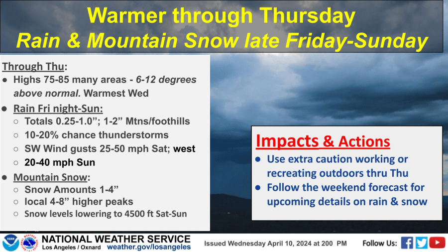
A Glimpse into the Forecast
Brace yourselves for a noticeable dip in daytime highs on Friday, with temperatures dropping about 10 degrees in most areas. By Saturday, when the rain arrives, Southern California will experience a significant cooldown, with highs hovering in the low to mid-60s.
While the rain won’t be a major downpour, expect scattered showers. Coastal areas and valleys will see less than an inch of precipitation, while mountain regions and foothills could receive up to 2 inches. The storm is expected to move out by Sunday.
The Precipitation Picture
Don’t expect a deluge, but this storm will bring some much-needed moisture.
Snow levels will dip to around 4,500 feet, resulting in 1 to 4 inches of snow at lower elevations and 4-8 inches on higher peaks.
The Aftermath
After the storm departs, Southern California can anticipate two more days of spring bliss with clear skies and daytime highs in the upper 60s and low 70s. So, cherish those moments, for they will be short-lived.
Stay tuned for further weather updates and advisories. LA News Center will keep you informed about any changes in the forecast.


